UPSC CURRENT AFFAIRS – 22 March 2025
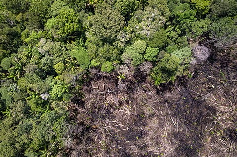
Transforming Forest Finance: Bridging the Gap Between Conservation and Destruction
Syllabus: Ecology
Context: A UNDP report highlights a significant funding imbalance, revealing that for every $1 invested in forest conservation, $6 is funnelled into industries that contribute to deforestation.
Key Insights from UNDP Report on Forest Conservation Funding:
- Funding Gap: $460 billion per year is required to stop deforestation, but current funding falls far short.
- Misaligned Investments: For every $1 spent on forest protection, $6 is directed toward deforestation-causing industries such as industrial agriculture and logging.
- Ineffective REDD+: Current payments under the REDD+ program range from $5–10 per tonne of CO2, while the actual mitigation cost is $30–50 per tonne.
- Debt Burden on Developing Nations: With $11 trillion in debt, developing countries are pressured to exploit forests for short-term financial relief.
- Successful Models: Direct funding to Indigenous communities, like the Mesoamerican Territorial Fund, has proven to deliver stronger forest conservation outcomes.
Governments Are Funding Destruction:
- Harmful Subsidies: Governments provide $500 billion annually in subsidies to industries driving deforestation.
Example: Subsidies for palm oil and soy production in Southeast Asia and South America.
- Debt-Driven Exploitation: High sovereign debt forces nations to prioritize economic gains over conservation.
Example: Debt-ridden countries like the Democratic Republic of Congo exploit forests for timber.
- Weak Regulations: Lack of stringent financial regulations allows banks to invest in deforestation-linked sectors.
Example: Major banks funding agribusinesses in the Amazon.
- Inadequate REDD+ Funding: Low payments under REDD+ fail to incentivize forest conservation.
Example: Brazil’s Amazon deforestation rates remain high despite REDD+ initiatives.
- Misallocation of Funds: Climate finance often bypasses local communities and Indigenous groups.
Example: Only 1% of global climate finance reaches Indigenous Forest stewards.
Consequences of Funds Fuelling Deforestation:
- Biodiversity Loss: Deforestation destroys habitats, leading to species extinction.
Example: Orangutans in Indonesia are critically endangered due to palm oil expansion.
- Climate Change: Forests act as carbon sinks; their destruction exacerbates global warming.
Example: Amazon deforestation contributes to rising CO2 levels.
- Economic Instability: Short-term gains from deforestation lead to long-term economic losses.
Example: Soil degradation from deforestation reduces agricultural productivity.
- Social Conflicts: Exploitation of forests displaces Indigenous communities.
- Water Cycle Disruption: Deforestation affects rainfall patterns and water availability.
Example: Reduced rainfall in the Congo Basin due to forest loss.
Way Ahead:
- Reform Public Finance: Increase funding for forest conservation through multilateral institutions like the World Bank.
Example: Redirect funds from harmful subsidies to sustainable alternatives.
- Overhaul Debt Systems: Address sovereign debt to reduce pressure on forest exploitation.
Example: Debt-for-nature swaps in countries like Ecuador.
- Strengthen Regulations: Mandate banks and investors to account for deforestation risks.
Example: EU’s deforestation-free supply chain regulations.
- Direct Funding to Communities: Ensure Indigenous and local communities receive financial support.
Example: Success of the Podáali Fund in Brazil.
- Innovative Financing Models: Establish long-term funding mechanisms like the Tropical Forest Forever Facility.
Example: Global funds for forest conservation similar to the Green Climate Fund.
Conclusion:
The UNDP report underscores the urgent need to realign global finance to protect forests. By reforming subsidies, strengthening regulations, and supporting Indigenous communities, the world can address deforestation and its devastating impacts. Immediate action is essential to safeguard forests, biodiversity, and climate stability.
PYQ:
- “The most significant achievement of modern law in India is the constitutionalization of environmental problems by the Supreme Court.” Discuss this statement with the help of relevant case laws. (UPSC-2022)
Mapping India’s Geospatial Intelligence
Syllabus: Space Sector
Source: DH
Context: China recently launched two high-resolution satellites under its Siwei Commercial Remote Sensing Satellite System, enhancing its geospatial capabilities. This development raises concerns for India, given its border disputes and economic tensions with China, highlighting the need for robust indigenous geospatial intelligence.
India and Its Geospatial Intelligence:
- Strategic Importance: Geospatial intelligence (GEOINT) is critical for national security, economic growth, and environmental management. It aids in monitoring border areas, tracking troop movements, and managing natural resources.
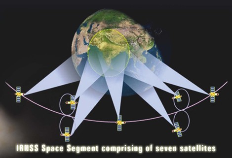
- Indigenous Systems: India developed NavIC (Navigation with Indian Constellation), positioning itself as the sixth nation with its own navigation system.
- Global Positioning: While the US’s GPS and China’s BeiDou dominate, India aims to carve a niche with NavIC, despite challenges in coverage and compatibility.
- Economic Applications: Geospatial data supports infrastructure development, agriculture, and urban planning.
- Security Concerns: Over-reliance on foreign systems like GPS poses risks, as seen in Russia’s GPS jamming during the Ukraine conflict.
Progress So Far:
- Policy Framework: The 2022 National Geospatial Policy eased data restrictions and encouraged private sector participation.
Example: Increased private investment in startups like Pixxel for hyperspectral imaging.
- Mission Integration: Geospatial technology is integrated into national missions like PM SVAMITVA for land digitization and Mission Mausam for weather monitoring.
Example: SVAMITVA’s success in mapping rural land parcels.
- Funding Allocation: The National Geospatial Mission received Rs 100 crore for 2025-26, signalling government commitment.
Example: Funds allocated for high-resolution satellite development.
- Private Sector Growth: Startups like SatSure and Dhruva Space are emerging as key players in the geospatial domain.
Example: SatSure’s use of satellite data for agricultural analytics.
- International Collaboration: India collaborates with agencies like NASA and ISRO for satellite launches and data sharing.
Example: NISAR, a joint NASA-ISRO satellite for Earth observation.
Challenges:
- Limited Investment: India’s geospatial budget is significantly lower than China’s and the US’s.
Example: China’s $1.4 trillion investment in geospatial technology.
- Data Policy Ambiguities: Unclear data-sharing policies hinder private sector growth.
Example: Delays in Pixxel’s satellite launches due to regulatory hurdles.
- Coordination Gaps: Multiple ministries oversee geospatial initiatives, leading to inefficiencies.
Example: Overlapping roles in PM Gati Shakti and SVAMITVA schemes.
- Technological Lag: India lags in high-resolution imaging and real-time analytics.
Example: China’s lead in multispectral and infrared sensing capabilities.
- Skill Gap: A shortage of skilled professionals in geospatial intelligence limits innovation.
Example: Limited specialized courses in Indian universities.
Way Ahead:
- Boost Investment: Increase funding for high-resolution satellite technology and AI-driven data processing.
Example: Allocate funds akin to China’s BRI for geospatial projects.
- Streamline Policies: Develop clear data-sharing frameworks to encourage private sector participation.
Example: Simplify licensing for satellite launches.
- Enhance Coordination: Establish a single nodal agency for geospatial initiatives to improve efficiency.
Example: Create a Geospatial Development Authority.
- Skill Development: Introduce specialized courses and training programs in geospatial intelligence.
Example: Collaborate with institutions like IIRS for skill development.
- Public Awareness: Promote the use of geospatial data in sectors like agriculture, urban planning, and disaster management.
Example: Launch campaigns to educate farmers on satellite-based crop monitoring.
Conclusion:
India’s geospatial capabilities are crucial for national security, economic growth, and global competitiveness. By addressing challenges like investment gaps, policy ambiguities, and skill shortages, India can strengthen its position in the global geospatial market. A focused approach, coupled with private sector innovation, will ensure India’s strategic autonomy and technological advancement.
PYQ:
- What do you understand by ‘Standard Positioning Systems’ and ‘Precision Positioning Systems’ in the GPS era? Discuss the advantages India perceives from its ambitious IRNSS programme employing just seven satellites. (UPSC-2015)
Use of AI in the Health Sector
Context: The Ministry of Health and Family Welfare has launched multiple AI initiatives to enhance healthcare delivery, with AIIMS Delhi, PGIMER Chandigarh, and AIIMS Rishikesh designated as Centres of Excellence for Artificial Intelligence.

About Use of AI in the Health Sector in India:
- Centres of Excellence for AI
- Institutions: AIIMS Delhi, PGIMER Chandigarh, AIIMS Rishikesh.
- Aim: Foster development and adoption of AI-based healthcare solutions.
- Media Disease Surveillance (MDS)
- What it is: An AI tool scanning digital media for infectious disease alerts.
- Outcome: Over 4,500 alerts published, aiding early outbreak prevention.
- Clinical Decision Support System (CDSS)
- What it is: AI integrated into e-Sanjeevani for AI-based differential diagnosis and patient data capture.
- Impact: Benefited 196 million consultations and aided 12 million diagnoses.
- Cough against TB
- What it is: AI-based community-level screening tool for pulmonary TB.
- Impact: 12-16% additional TB case detection in deployed regions.
- Prediction of Adverse TB Outcomes
- What it is: Predictive AI solution to identify TB patients at high risk of complications.
- Impact: 27% reduction in adverse outcomes since deployment.
22 March 2025 Facts for Prelims (FFP)
Coal Production in India
Source: PIB
Context: India has achieved a historic milestone by surpassing 1 billion tonnes of coal production in FY 2024–25, a feat hailed by Prime Minister as a proud moment reflecting energy security and self-reliance.
About Coal Production in India:
Historical Background:
- Commercial coal mining in India began in 1774 at Raniganj Coalfields along the Damodar River.
Nationalisation of Coal:
- Coking coal mines nationalised in 1972 under the Coking Coal Mines Act.
- Non-coking coal mines nationalised in 1973 under the Coal Mines (Nationalisation) Act.
Categories of Coal in India:
- Gondwana Coal:
- Age: Formed around 250–300 million years ago (Permian period).
- Location: Found in peninsular India.
- Major States: Jharkhand, Odisha, Chhattisgarh, West Bengal, Madhya Pradesh, and Maharashtra.
- Characteristics:
- High carbon content and high calorific value.
- Contains moisture and volatile matter.
- Mostly bituminous and sub-bituminous in nature.
- Uses: Primarily used for power generation, steel production, and industrial purposes.
- Tertiary Coal:
- Age: Formed around 15–60 million years ago (Tertiary period).
- Location: Found in northeastern states and parts of Jammu & Kashmir.
- Major States: Assam, Meghalaya, Arunachal Pradesh, Nagaland, Jammu & Kashmir, and Rajasthan.
- Characteristics:
- Higher moisture content and lower carbon concentration.
- Mostly lignite or peat with lower calorific value.
- Uses: Used for power generation and domestic heating.
Types of Coal in India:
- Anthracite: Highest carbon content (80-95%), found in Jammu & Kashmir.
- Bituminous: 60-80% carbon content, found in Jharkhand, Odisha, West Bengal, Chhattisgarh, and Madhya Pradesh.
- Sub-bituminous: Dull black coal, higher energy than lignite.
- Lignite: Low carbon content (40-55%), found in Tamil Nadu, Rajasthan, and Assam.
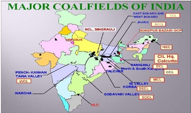
Major Coal Producers in India:
- Coal India Limited (CIL): Largest contributor with 773.81 MT production in FY 2023-24.
- Singareni Collieries Company Limited (SCCL): Key supplier for southern India, produced 70.02 MT in FY 2023-24.
- Captive and private players: Increasing contributions post-coal sector reforms.
Top Coal Producers in the World (Rank-wise):
- China – Largest producer globally, contributing around 50% of world production.
- India – Second-largest coal producer with over 1 billion tonnes produced in 2024-25.
- United States – Major exporter and consumer, ranking third globally.
Coal Producing States in India (Rank-wise):
- Jharkhand – Largest reserves and major coking coal source.
- Odisha – Large contributor with major thermal coal mines.
- Chhattisgarh – Key producer with some of the world’s largest coal mines.
- West Bengal – Historic coalfields such as Raniganj.
Important Coal Mines in India:
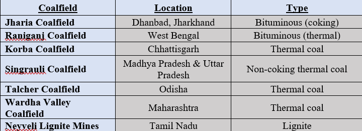
Also in news:
- Chhattisgarh-based Coal India subsidiary South Eastern Coalfields Limited’s (SECL) Gevra and Kusmunda coal mines have secured the 2ndand 4th spot in the list of the World’s 10 largest coal mines released by WorldAtlas.com in 2024.
Stockholm Water Prize 2025
Source: DTE
Context: Günter Blöschl, a renowned hydrologist, has been awarded the 2025 Stockholm Water Prize for his pioneering research on flood risks and climate change impacts globally.

About Stockholm Water Prize 2025:
- What it is: An internationally acclaimed water award recognizing outstanding achievements in water science, management, and protection.
- Awarded by: Presented by the Stockholm Water Foundation in collaboration with the Royal Swedish Academy of Sciences.
- Origin:
- Established in 1991 as part of the Stockholm Water Festival, celebrating Sweden’s commitment to clean water.
- Who are awarded:
- Individuals or organizations with exceptional contributions to water conservation, management, and sustainability.
- Laureates come from diverse fields including science, engineering, policy, and environmental advocacy.
- Features:
- Presented annually by King Carl XVI Gustaf of Sweden during the World Water Week in August.
- Nominations can be made by anyone (except self-nominations or close relatives).
- The Prize Committee shortlists candidates, and final approval is done by the Board of the Stockholm Water Foundation.
- First Winner:
- Professor David W. Schindler (Canada, 1991), recognized for contributions to understanding pollution and climate impacts on lakes.
- 2025 Winner and Contribution:
- Günter Blöschl, Professor at Vienna University of Technology.
- Recognized for revolutionizing flood risk assessment and developing observation-based climate-flood connections.
UN Water Development Report 2025
Source: UN
Context: The United Nations released the UN Water Development Report 2025, highlighting glacier preservation as a global priority.
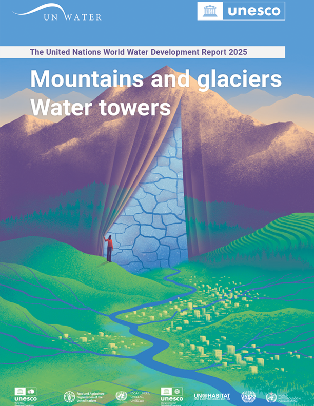
About UN Water Development Report 2025:
- What it is:
- A flagship report published annually by UN-Water providing policy insights and data on global water and sanitation issues.
- Report Name: “Water Towers: Mountains and Glaciers” (2025 Edition).
- Published by: UNESCO World Water Assessment Programme (WWAP) on behalf of UN-Water.
- Key Insights in the Report:
- Highlights the role of mountains and glaciers as key water sources supporting billions worldwide.
- Warns of glacial retreat due to climate change and its cascading effects on water scarcity.
- Calls for integrated water resource management (IWRM) and transboundary cooperation to address water crises.
- Advocates for mountain-specific policies, better monitoring infrastructure, and community engagement.
- Emphasizes the need for innovative climate adaptation financing to protect water towers globally.
About World Water Day 2025:
- Date Celebrated: Annually on March 22.
- Theme for 2025: “Glacier Preservation” – focusing on safeguarding glaciers as vital freshwater reserves.
- History:
- First proposed at the 1992 UN Conference on Environment and Development (UNCED) in Rio de Janeiro.
- Officially established by the United Nations General Assembly in 1993.
- Significance:
- Raises awareness about global water challenges and the need for sustainable water management.
- Highlights climate impacts, water scarcity, and pollution threats to freshwater resources.
SwaYaan Initiative
Source: PIB
Context: The Ministry of Electronics and Information Technology (MeitY) and Drone Federation of India launched the National Innovation Challenge for Drone Research (NIDAR) under the SwaYaan initiative.

About NIDAR:
- What it is:
- National Innovation Challenge for Drone Application and Research (NIDAR).
- Part of:
- Launched under the SwaYaan – Capacity Building for Human Resource Development in Unmanned Aircraft Systems (UAS) initiative.
- Ministry:
- Ministry of Electronics and Information Technology (MeitY) in collaboration with Drone Federation of India (DFI).
- Aim:
- Encourage research, innovation, and real-world drone applications in disaster management and precision agriculture.
- Engage over 100 student teams for developing autonomous drone solutions.
- Foster startup incubation, cloud credits, software support, and internships.
About SwaYaan Initiative:
- What it is:
- A comprehensive capacity-building program for drone and allied technologies in India.
- Launched in: Approved by MeitY in July 2022.
- Ministry: Ministry of Electronics and Information Technology (MeitY).
- Aim:
- Train 42,560 participants to create a skilled drone technology workforce.
- Features:
- Implemented via a hub-and-spoke model with participation from 30 top institutions including IISc, IITs, IIITs, NITs, CDAC, and NIELIT.
- Focus areas include Drone Electronics, GNC Algorithms Simulation, Aeromechanics, Drone Applications, and Allied UAS Technologies.
- Initiation of minor degree programs, bootcamps, and workshops.
- Active industry participation through challenges and innovation platforms.
CURRENT AFFAIRS – 22 March 2025 Mapping:
Suriname
Source: DD News
Context: India has sent machinery worth $1 million to Suriname to support the growth of its passion fruit industry as part of the India–Suriname development partnership.
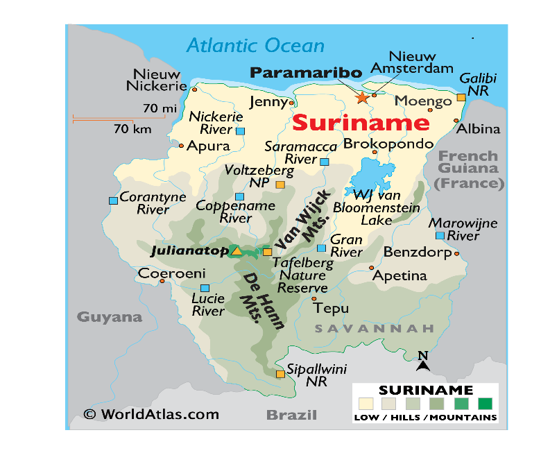
About Suriname:
- Location:
- Suriname is located on the northern coast of South America.
Namibia
Source: TH
Context: Namibia has sworn in Netumbo Nandi-Ndaitwah as its first female president, becoming Africa’s second directly elected female head of state.
- The first African nation to have a woman as the head of state through direct election was Liberia.
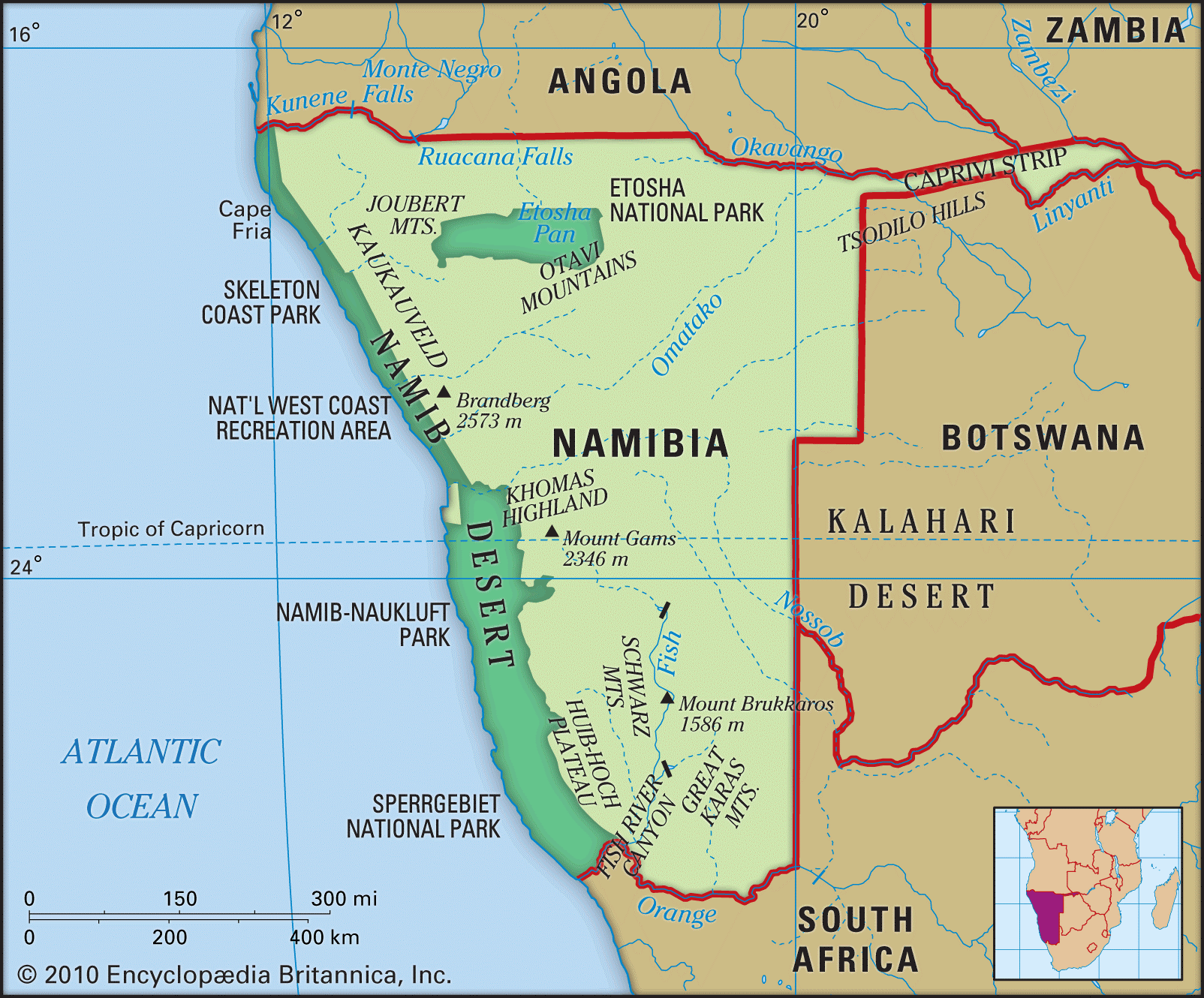
About Namibia:
- Location: Situated on the southwestern coast of Africa.
- Capital:
- Neighbouring Nations:
- Borders Angola (north), Zambia (northeast), Botswana (east), South Africa (south), and the Atlantic Ocean (west).
- Geographic Features:
- Rivers: Permanent rivers include Kunene, Okavango, Zambezi, Mashi, and Orange River.
- Mountains: Brandberg Mountain is the highest peak (2,573 meters).
- Topographic Zones: Coastal Namib desert, Central Plateau, and the Kalahari region in the east.
- Major Crops:
- Millets, maize, sorghum, and vegetables are cultivated in the northern fertile regions.